Search This Blog

Pages

Local Walk: Kelsey Gardens and Keyingham (3.8 miles)

Tuesday, 31st December 2019

Final walk of the year.  And what a lovely one it was too.

Given the harsh frost in the morning, I wrapped up warm - my positively ancient "winter duvet" jacket being dragged out of hibernation yet again.  One day I'll find a suitable replacement that doesn't cost £350+ !

I didn't fancy an out of the door walk so I decided to take some pennies with me and have a bacon sarnie and cuppa at the butty shack at Kelsey Gardens.

I traveled the 10 minutes to the parking spot, hoping nobody else was there on such a glorious day - bright blue skies and not a breath of wind.  Nobody else was there and I hogged the bit without the giant puddle.

And off I set.


I set off along the (initially) nice, easy disused railway track.  Breathe deeply.... aaaaand relax.  The sun was out, the birds were chirruping away and there wasn't much traffic on the road I was leaving behind.  Lovely.

Further along the track it gets really rutted and turns into an impassible swamp and this is where I decided to do a little trespass by cutting down through the scrubby hawthorn and onto the farmer's field where there is a wide, grassy strip - mainly used by horseriders by the looks of things.  It wasn't exactly dry underfoot, but at least I didn't need waders!

Towards the end of the field I cut back onto the railway line again then changed my mind, deciding to extend my walk and follow Keyingham Drain for a while to the little bridge.  I noticed just how much the drain had burst its banks as I walked along - the flattened bulrushes giving a false impression of solid ground. 

As I reached the bridge I remembered that previously I had vowed never to walk this way again after rain, or in winter, or in fact any time when there hadn't been a severe drought the days before and I eyed up the mudbath, sorry footpath, across the field in front of me.

Nice view back along Keyingham Drain from the bridge though.


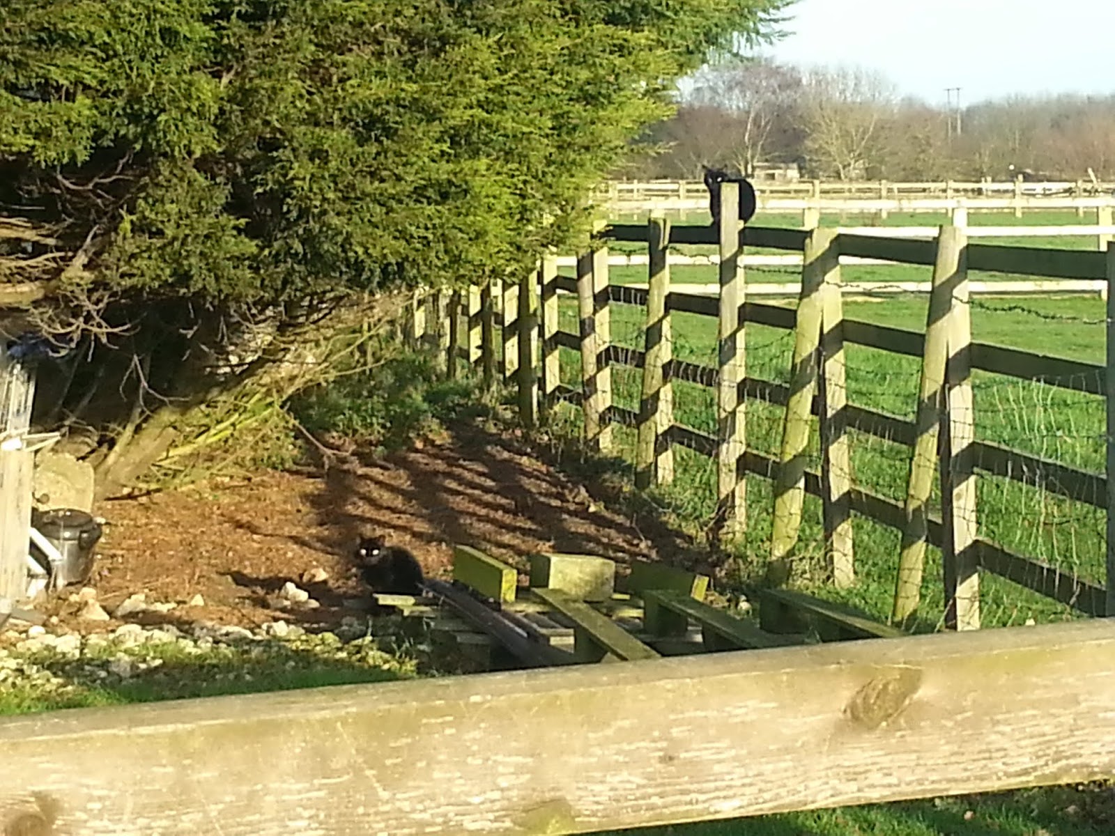
Mudbath negotiated, I climbed up the hill (yes, a hill!), watched curiously by two black cats.  Can you spot them?


At the top of the hill I entered the village (Keyingham) and decided to walk through the Church grounds, to be greeted by another cat!

Walking through the village I chatted to a few other folks who were out for a "Sunday Stroll" or walking their dogs, before turning off again along the other end of the railway track.

The sun was more in my face now and I wish I'd brought my sunglasses. Then again, why would I want to stop natural daylight hitting my eyeballs when I spend far too much time in artificially lit boxes?!

I noticed the fields were more flooded than normal for this time of year.  Not surprising really given the amount of rain we had in November.


Happy that I'd worked up enough of an appetite for my bacon sarnie and cuppa now, I headed to Kelsey Gardens, only to discover that the butty shack was closed!  Well ain't that just typical! I normally carry a snack and drink with me on this walk and feel guilty eating it here if the butty shack is open.  Today, I'd brought neither in anticipation of a New Year's Eve treat - their bacon sarnies are yummy, if a tad pricey.

I wandered around a bit but a lot of the paths have been closed off for maintenance (an ongoing project of the not so new now management).  I hopped under/over a couple of barriers though to get this pic across South Lake..


I know the last time I was talking to Ian (manager) he was hoping to re-open the path round the South Lake to create a sort of figure of eight walk around the two lakes and I hope that these closures mean that is in process.  I remember walking round South Lake when I was (a lot!) younger and it was a nice, lumpy, bumpy path with a steep drop into the water if you lost your footing!

Leaving Kelsey Gardens with my tummy protesting loudly at the false promise of food I decided to walk along the quiet lane past "Steptoe's Yard" with some sort of idea of cutting through the woodland to the driveway of Kelsey House.  I couldn't find the path from this side and there were people in the caravan near where I was poking about that might have started to get suspicious if I'd have walked past their "front door".  Then again, I'm not sure they should have been in the caravan so I'll say nowt if they don't.

Instead, I continued along the lane and enjoyed some far reaching (if flat) views..


.. as I followed the lane to the main road for the final and least pleasant part of the walk as there's no footpath and cars come tear-arsing along the road.  At least there's a wide verge for the most part and I tried my hardest to get rid of the clay mud off my shoes by walking through the long grass.

I could see my car a short distance away and sorely wished I'd put my pretend crocs in there to change into rather than muddying up the footwell!  Hey ho.  It'll dry and I'll hoover it out ... in about June I expect!

A right nice little walk it was and I returned home to cook my own bacon sarnie (shock).

Once again, no tendon issues, no hip issues and no back issues at all and I could quite happily have walked a lot further than I did.  I'm heading into the New Year feeling quite hopeful I can get out and about a bit more for a few longer walks.

Today's walk also completed my Challenge365 Mile A Day For A Year project, clocking off with a pleasing 367.21 miles.

Happy Days.  

Parking: Hariff Lane junction with railway track (free)
Distance: 3.8 miles
Max height: 57 ft

Thanks for looking 


Local Walk: Beverley and the Westwood on POETS Day!

Friday, 27th December 2019

We got a flier from work today.  I suspected we would, so I took my walking shoes and troos with me in anticipation!

Having not had "the nod" from SHQ before noon, I dashed out to Tesco for some some bits and bobs and took the long route back to get my mile in for the day, only to return back and my colleague said we'd had "the nod" and could go after 1pm.  

After a quick flurry of productivity(!!) and, after a quick change of clothes, I was away.  Lunch on Beverley Westwood in the murk?  What more could you ask for?!!

I decided to walk to the North Bar Within / Without entrance to the Westwood and do a giant anti-clockwise loop via the racecourse, the mill and the woodland path back.


The lack of signage under "The Westwood" told me there's no cows on there at the moment, which was a relief.

But yeah, my head was in the clouds (metaphorically) and I followed the families and dog walkers along the woodland path instead.  So off I trotted across the road and went off-piste over somewhat squishy rough grazing pasture, leaving the crowds behind (but not the sound of traffic).  It's such a shame that this ancient patch of common land is bound on all sides by busy roads.

I squelched along aimlessly, deliberately choosing the roughest ground and steepest gradients (I use the word "steepest" loosely!) as a bit of a training exercise for my upcoming hols  I heard the many Churches in Beverley chiming 2pm which reminded me I'd not had my lunch yet so I made a bee-line for Black Mill where there are benches.

As I got higher up I noticed the murk and mizzle rolling in but, hey, I'd rather be here in that than sitting at my desk!


Arriving at Black Mill, I mentally willed all the people who seemed to arrive at the same time as me to sod off.  They obliged, and I enjoyed my sarnie in relative solitude.

I could feel the mizzle on my face now and the wind was picking up so I headed down towards the golf course, again taking the roughest, steepest ground I could find.  I didn't expect to see anyone playing golf today so just wandered around a bit.  I did discover some strange ... containers .... fixed on posts in the bushes.  On closer inspection it turns out they are snazzy little devices to clean muddy balls.  Golf balls I presume.  Though I did wander off with some odd thoughts going through my mind for a while afterwards (stop sniggering!).

After crossing the other road I took the direct route up to a stand of trees near the Racecourse.  There is a memorial stone in the trees but, given the recent rain, I decided to give paying it a visit a miss as the area was a slippery, muddy swamp.  Instead, I continued along the edge of the Racecourse for a while before dropping back down to re-cross the road and head up the other side, this time skirting round the other side of the woodland path I first walked in on.

From there, it was a simple case of heading to the first road I crossed and returning to civilisation.  The rain had started properly now so I reckon I timed it just right.

Four miles to go now to reach my Challenge365 Mile A Day For A Year target and four days to do it in.  By Jove I think I'll manage it!

No Achilles tendon problems either.  I could get used to this walking without pain malarkey.

Parking: At work
Distance: 5.1 miles
Max height: 131 ft

Thanks for looking 


East Yorkshire: Paull Foreshore (2.6 miles)

Monday, 8th December 2019

First non-functional and daylight walk in ages!  

I had an hour or two to spare earlier today so, seeing as the sun was shining, I decided to head out to my "pick me up and blow away the cobwebs" walk on Paull Foreshore.  I also wanted to see what they'd done with the flood embankments which have been closed off for nigh on a year for shoring up.

I parked up at the Village Hall because the muddy quagmire at the end of the village was full and set off, deciding to do the walk in reverse to my normal way to mitigate the harsh and bitter wind rattling up the Humber and blowing at my back.  Within minutes my eyes were streaming and my nose was running!

Not that you can see it clearly at all but here is a Curlew grazing on the playing field:

Bit of signpost OCD:

Mandatory pointless gate pic, with the two equally pointless lighthouses beyond:

New info board at the bird hide:

I headed onto the newly re-opened shored up flood embankment.  All it looks like they've done is stick some boulders at the base of the bank and gravelled the top to make it less of a mud-bath:

I'm not sure if there are any aeroplanes other than the Red Arrows who would loop the loop and have smoke (not vapour) trails but I was treated to an evening display flying over the Lincolnshire Wolds:

Tide's in on the mudflats, with ship sailing beyond in the Humber:

Paull Church:

Aircraft (a Blackburn Beverley) at Fort Paull:

Entrance to Fort Paull just before I headed into the woodland:

It would seem I forgot that it gets dark at around 4pm and I finished my walk through the woodland with my eyes in night vision mode.  What was that snuffle? Twig cracking? Those luminous eyes in the trees?

Once out of the woodland it was a short meander across the playing field back to my car.

A right nice little moochabout.  Enjoyable, as always.


Thanks for looking 

Derbyshire - Froggatt, Curbar and White Edges (6.4 miles)

Sunday, 27th October 2019


Met up with Ed for another forum meet in the Peak District.

Travelling there this time was blissfully uneventful and I arrived at the layby, snaffling the last parking spot.

I had a leisurely faff about, eating my breakfast (an apple), getting my phone GPS cranked up and my walking shoes on.  It got to about 10.10am and I decided that Ed was unable to make it after all so I set off down the road.

Just before turning off the lane to the National Trust car park I heard someone calling my name and turned to see Ed waving.  So I pootled back up the road to him.

We got set off (back down the way I’d just walked) and headed through the woodland to the stream.  There was plenty of water in it and I was ever so slightly apprehensive about crossing it via the bouldery rocks as my balance isn’t that great.  Ed led the way and I inelegantly  clambered across after him.

Obstacle navigated, it was a short, stiff climb away from the stream and up to the road, which we crossed and headed through a gate and onto the beginnings of Froggatt Edge.

Before long, we spotted our first rocky outcrop:


Somewhere along the path there is a stone circle and we were given some duff information by a couple walking past.  It wasn’t there and we forged a squishy path through some scrubbly woodland before returning to the main path again.  Eagle-eyed Ed spotted it in the end (he has a pic).

Views kept appearing through the trees across the Derwent Valley:


Eventually we got onto Froggatt Edge “proper” and followed the “motorway” for a while, occasionally taking the time to dip in and out of the rocky outcrops and ledges:


I took a snap of the view up onto White Edge – there were hordes of people walking along it and I voiced my doubts about seeing any deer/stags with that many people about:


We arrived at Jolly’s Tea Van at Curbar Gap car park where Ed partook of a coffee and I had a bag of crisps - to fortify ourselves for the stiffest climb of the day up onto White Edge.

Leaving the car park we headed East onto a farm track.  A nice sign pointed us in the right direction:


... and spotted this:

A bit of poetry carved into a slab of stone. Sometimes poetry is very strange 

I was relieved to see that the worst part of the climb up onto White Edge had been paved – the last time I was here it was just a slippery, grassy trod and, given the rain we’ve had recently, I was expecting it to be a mudbath/swamp/skating rink and anticipated having to do a little contour line traversing to avoid it.

The start was still a little muddy but nothing un-navigable, with a nice little stone bridge over the stream.  I checked for trolls but none were found: 

After the initial stiff climb, it returns to the more gentle gradient I was comfortable with and Eagle-eyed Ed spotted a herd of deer away in the distance  (he has pics).

After that, it wasn’t long before the trig pillar came into view:


Or, rather, it would have come into view if it hadn’t been photobombed by a dog!

I touched the top, at 365m above sea level, this is the highest I’ve been in a looooooong while and .It .Felt .Goooooood 

The views were fantastic.  Autumnal moorland topped with bright blue skies and fluffy clouds – perfect:


I was disappointed, but not surprised that there weren’t masses of stags burbling and rutting everywhere but there were still plenty of people around which was probably making them keep well away and pretty much out of sight.

However, we did spot a few bachelor stags away off in the distance and a few does hidden in the moorland and it was only by using the zoom function on the camera that we could confirm they weren’t rocks!  The zoom photographs I took were absolutely pants. 

It was about time for a snack stop and I spotted a large rocky outcrop a little off the beaten track to sit behind, out of the wind, with good views over Big Moor (and hopefully stags).  It can’t have been the same place I stopped at before as I don’t remember finding a smashing little stone shelter with seats, which is what we ended up sitting in.  Quite pleasant out of the wind it was.

See if you can spot the stags:


After quite a leisurely snack stop we rejoined the blustery path.  I’m not sure if it was because we’d changed direction slightly or what but the wind seemed stronger (and colder) than before.

The path along White Edge is lovely.  Nice and rough and ready with rocky bits and peaty bits and sandy/gritty bits and has a much more wild feeling that Froggatt and Curbar Edges.  After negotiating a couple of impromptu streams gurgling up and out of the moorland and off down the hillside we spotted some more stags and does to our left this time: 


We stood a while and watched one particular stag who obviously fancied his chances with the ladies but his Chosen One was having none of it 

From there, it was an interesting gentle uppy and downy ridge-walk:


…. to the Hurkling Stone:


No, this isn’t the Hurkling Stone that’s on the more familiar Derwent Edge and I’m not convinced that the definition of “crouching” means much of anything at all.  Both (that I’m aware of) are on the end of a long ridge and I wonder if they’re more a precursor to a modern day cairn – a visual signal of the end of a ridge.  Anyway, I digress.

At the wall just beyond, we took a left turn down to follow it back to our cars.  Shortly after commenting to Ed that I remembered it being steeper and rocker than “this”, the steep and rocky bit appeared and, again, I turned into a wuss at climbing down – despite it only being, oooh, what….. 10 feet of horribleness.  I’d have been fine going up it mindst.

From there we entered a lovely little patch of woodland:


Before squelching across a rather waterlogged field and back to the cars:


All in all, a right grand autumnal day out, despite not being overrun with rutting, burbling stags 

Finally, here’s a computerified zoom in of a zoom in of a stag:


I need a better camera.

This is the second "proper walk" I've done where I've had absolutely no tendon issues whatsoever.  I'm quietly hopeful that a combination of walking shoes, losing a bit of weight, yoga and regular but shorter walks at a leisurely pace has contributed to its improvement.  Fingers crossed eh?


Parking: Layby nearest The Grouse Inn (free)
Distance: 6.4 miles
Max height: 1,216 ft

Thanks for looking